|
|
| Date: |
|
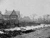
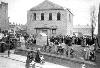
| Description: | Maps of 1840 show that only Castle Street in Portchester was developed as a residential area except for some houses in West Street and the corner of East Street. At this time it was also known as South Street. The houses were spaced out in intervals and White Hart Lane was without any buildings at all except for some cottages at the eastern junction with Castle Street. There was the White Hart beerhouse with shops alongside. The brewery for the White Hart was on the opposite side of Castle Street. On the other corner lived the Pharoah family, which later was the Parish Hall. From the Pharoah cottage towards the castle was an open space before another cottage, then the Methodist Chapel, followed by a short row of terraced houses. Later, the Chapel moved to a newer chapel in Castle Street opposite Cow Lane, then again to nearer the crossroads. Castle Street continued towards the castle, both sides having small cottages and houses.
Reference:
1. Crouch, George T. Story of Portchester, p. 35-37, 47.
Copy photograph of an engraving. | | Format: | image/jpeg | | License: | http://www.sopse.org.uk/ixbin/hixclient.exe?a=query&p=gateway&f=generic_sitetext%2ehtm&_IXFIRST_=1&_IXMAXHITS_=1&cms_con_core_subtype%3acms_con_text_what=copyright&%3acms_sys_group=%22sopse%22 | | Rights holder: | Hampshire Library and Information Service - Hampshire County Council | | Subjects: | Castle Street
building
White Hart
donkey
street
horse
house
chapel
Pharoah
transport
beer house
Portchester Castle
castle
Methodist
Parish Hall
keep | | Temporal: | start=1820-01-01; end=1840-12-31; | | Source: | Sense of place SE | | Creator: | Copied by: Dine, Derek; Hampshire County Library; | | Identifier: | http://www.sopse.org.uk/ixbin/hixclient.... | | Language: | en-GB | | Format: | image/jpeg | | Go to resource |
|
|


