|
|
| Date: |
|
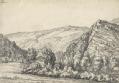
| Description: | Draughtsmen would sometimes rotate the area they were mapping to fit in to the available paper. Hence, this map is not orientated with north at the top. Earthworks around Ashburton and Ashburton Down, near the bottom of the drawing, are depicted by short, open, circular strokes ('hachures') in black. Around Holne Chase, to the left of the picture, feathered arrows describe the flow of the River Dart beyond two points of confluence. | | License: | http://www.bl.uk/services/copy/permission.html | | Rights holder: | British Library | | Subjects: | Cartography And Topography
Maps | | Source: | Collect Britain | | Creator: | [Dawson, Robert] | | Identifier: | http://www.collectbritain.co.uk/personal... | | Language: | en-GB | | Go to resource |
|
|