|
|
| Date: |
|
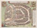
| Description: | This map of London, Westminster and Southwark was issued in Peter Van der Aa's "La Galerie Agreable du Monde: Grande Bretagne et Irlande" (Vol. I, Plate 8). It is a later edition of a map first published in Amsterdam by Joannes de Ram at the end of the 17th Century. This edition features title along the top, a key to places in Southwark in cartouche at top left, a reference table at top right, and a bird's-eye view of Westwood Park in Worcestershire at the foot of the plate. The city arms, publisher's imprint, and a monument bearing the title in French appear towards the bottom of the sheet. | | License: | http://www.bl.uk/services/copy/permission.html | | Publisher: | Aa, Peter van der | | Rights holder: | British Library | | Subjects: | London maps | | Source: | Collect Britain | | Creator: | Aa, Peter van der | | Identifier: | http://www.collectbritain.co.uk/personal... | | Language: | en-GB | | Go to resource |
|
|