|
|
| Date: |
|
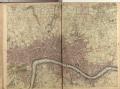
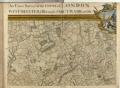
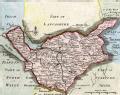
| Description: | This map was first published by Rocque in 1746, and several editions appeared before his death in 1762. His widow Mary Ann carried on the business for a few years, until, in the late 1760s, she transferred the plates of the map to the publishers Carrington Bowles and Robert Sayer, under whose imprints this edition appeared in 1769.
Printed in 16 sheets, the map is set within a decorative border. Its title features in English, Latin and French along the top, with emblematic figures below the City arms at top centre, and the compass star at top left. The map is dedicated to Lord Burlington at bottom centre. Scales are given at the foot of the map in versts, leagues, toises, yards and miles. A key to symbols distinguishing orchards, arable land, formal parkland and gardens, pasture, and woodland is included at bottom right. The "New Road" (Marylebone Road), Blackfriars Bridge and the roads across St George's Fields are also shown. | | License: | http://www.bl.uk/services/copy/permission.html | | Publisher: | Sayer, Robert & Bowles, Carrington | | Rights holder: | British Library | | Source: | Collect Britain | | Creator: | Rocque, John | | Identifier: | http://www.collectbritain.co.uk/personal... | | Language: | en-GB | | Go to resource |
|
|