|
|
| Date: |
|
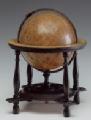
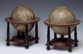
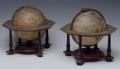
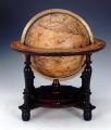
| Description: | Terrestrial table globe. It forms a pair with the anonymous celestial globe, GLB0163. Geographical details on the sphere show an area with the most northern point labelled 'C. Kinja'. North America is labelled 'AMERICA SEPTENTRIONALIS' and its western extension 'Nova Albion'. California is drawn as an island. There are labels for 'Buttons Bay' and 'Hudson Bay' with a related note. South America is labelled 'AMERICA MERIDIONALIS sive PERUVI'. At Cape Horn, there are labels 'Fretum Magellanicum' and 'Fretum le Maire'. Near the coast of New Guinea, there is a note.
The Dutch discoveries of Australia up to 1644 are shown. There is no hypothetical southern continent but only a label in the south polar area 'TERRA AUSTRALIS INCOGNITA'. A total of 11 oceans are named. The isle of 'Iapan' has no boundary on the northern side.
The open structure of Japan is found only on the maps and globes of Jacob Colom, who published in Amsterdam. The globe bears many other similarities with his maps, but several names are missing in the copy. See also notes for GLB0163. For full details about the cartography and construction of this globe please refer to the related publication.
caption: Terrestrial Globe by Wright(?)
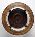
caption: Horizon ring
caption: Sphere and stand | | Publisher: | "http://collections.rmg.co.uk/" | | Rights holder: | "Royal Museums Greenwich" | | Subjects: | Globes at Greenwich
Terrestrial globe
Captain James Cook Navigator
terrestrial globes
Table globe | | Source: | Royal Museums Greenwich | | Identifier: | http://collections.rmg.co.uk/collections... | | Go to resource |
|
|