|
|
| Date: |
|
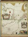
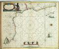
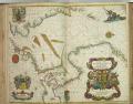
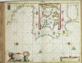
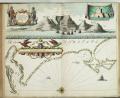
| Description: | Bound sheet. Hand col engr. Scale: [ca. 1:250 000 (bar)]. Cartographic Note: North at 90 degrees. Borders graduated for latitude. Bar scales in English miles. Contents Note: Contains an inset of the River Thames, N at 180 degrees, scale ca.1:150 000 (bar). Contains a list of names of the sands and shoals. The title cartouche incorporates cherubs with surveying instruments and the arms of the Duke of York. Decoration also includes the arms of Trinity House. A chart from 'Atlas Maritimus', or the Sea Atlas; being a book of maritime charts.
caption: PBE6862, Seller Atlas Maritimus, s'foreland to Orfordness | | Publisher: | "http://collections.rmg.co.uk/" | | Rights holder: | "Royal Museums Greenwich" | | Source: | Royal Museums Greenwich | | Identifier: | http://collections.rmg.co.uk/collections... | | Go to resource |
|
|