|
|
| Date: |
|
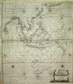
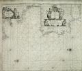
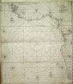
| Description: | Bound sheet. Engr. Scale: [ca. 1:14 500 000 (bar)]. Cartographic Note: North at 270 degrees. Border graduated for latitude. Bar scales in Dutch and Spanish miles, English and French miles [actually leagues]. Additional Places: Indian Ocean.
A chart bound in Jacob Colom's Atlas of werelts-water-deel en des selfs zee-custen, 1663. The number 15 is in the lower right corner.
caption: PBD8028, Colom, Werelts-Water, Oost Indien | | Publisher: | "http://collections.rmg.co.uk/" | | Rights holder: | "Royal Museums Greenwich" | | Source: | Royal Museums Greenwich | | Identifier: | http://collections.rmg.co.uk/collections... | | Go to resource |
|
More Like this...
-
 Oost Zee Oost Zee
Bound sheet. Engr. Scale: [ca.…
-
-
-
-
-
-
-
-
-
|