|
|
| Date: |
|
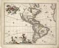
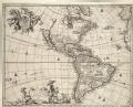
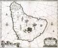
| Description: | Single sheet. Engr. Medium: 2 sheets joined at centre. Scale: [ca. 1:300 000]. Cartographic Note: Graduated for lat & long. Mercator projection (with explanation - see General Note). Rhumbs. Scale in German miles. Additional Places: Patagonia, Tierra del Fuego, Straits of Magellan. Contents Note: Sea decorated with ships. Scale cartouche supported by Patagonians. Inset notes of locations.
From Blaeu's Atlas. Latin text description of Magallanica (pp192-193) verso. This chart is particularly notable for the 'chequerboard' scale indicating how, with Mercator's projection, distances are increased towards the poles.
caption: G279:4/37 Tabula Magellanica by Blaeu | | Publisher: | "http://collections.rmg.co.uk/" | | Rights holder: | "Royal Museums Greenwich" | | Source: | Royal Museums Greenwich | | Identifier: | http://collections.rmg.co.uk/collections... | | Go to resource |
|
|