- Back
-
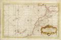
Title: 2mee Carte Particliere des Costes de Normandie contenant les costes du Cotentin depuis la Point de la Penee jusqu' a Granville ou sont conprises les Isles de Jersey Grenezey Cerz & Aurigny avec les Isles de Brehat H Van Loon sculp [Go to resource]

Description: Scale: circa 1:200,000. Chart of the north coast of France, Cherbourg Peninsula and the Channel Islands. Prime meridian probably on the Canaries. Rhumb line grid. Coordinates given. Publisher: "http://collections.rmg.co.uk/" Source: Royal Museums Greenwich Identifier: http://collections.rmg.co.uk/collections... Go to resource More Like this...
[Edit] - Back


- Home |
- About |
- Add |
- Use |
- Contact us