|
|
| Date: |
|
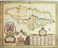
| Description: | Copper plate engraving of Barbados by John Ogilby. Graduated for latitude, scale in English miles. Anchorages and rocks are indicated around the coast and rhumb lines cover the entire sheet. Plantations are named and crops are depicted and labelled. There is a scene of slaves at work.
This record was added as part of the 2009-2010 pre 1900 charts transcription project.
caption: Map of Barbados by John Ogilvy, mid 17th Century | | Publisher: | "http://collections.rmg.co.uk/" | | Rights holder: | "Royal Museums Greenwich" | | Source: | Royal Museums Greenwich | | Identifier: | http://collections.rmg.co.uk/collections... | | Go to resource |
|
|